Applied Imagery is pleased to announce the release of QT Modeler 8.3.2 is a professional three-dimensional point cloud processing and terrain visualization software.
Explore he new features of Quick Terrain Modeler 8.3.2.
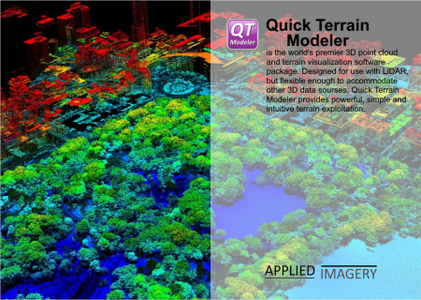
Quick Terrain Modeler is the world’s premier 3D point cloud and terrain exploitation software package. Designed for use with LiDAR, but flexible enough to accommodate any 3D data source, Quick Terrain Modeler provides an easy to use software experience that allows users to work with huge 3D data sets, quickly analyze that data, and export a wide variety of export products – all with a minimum of training and experience.
Applied Imagery was founded in 2004 in Silver Spring, MD, a suburb of Washington, D.C., to commercialize software developed at Johns Hopkins University’s Applied Physics Lab (APL). Our commercial, off-the-shelf (COTS) software, the Quick Terrain Modeler, is the world’s premier 3D point cloud and terrain exploitation software package. Quick Terrain Modeler is focused on DoD and civilian applications and continues to evolve based on customer feedback. Of note to Government customers, Applied Imagery is designated as a small business and is the sole source for the Quick Terrain Modeler in the United States.
解压密码:caxfwz


请先 !