开放城市地图连接版更新16发布说明
宾利很高兴地发布了OpenCities地图CONNECT Edition Update 16,这是OpenCities地图产品的一个新版本,提供2D / 3D桌面GIS和地图,可以立即下载。OpenCities地图PowerView、OpenCities地图高级、OpenCities地图终极三个版本,以及OpenCities地图高级SDK都已经发布。
注意:更新编号已调整为与Power Platform / MicroStation更新编号一致,7.1至16之间没有更新。
New Features and Capabilities
New Map Configuration Ribbon Group: These tools are designed to elevate your File-based CAD designs to Geospatial data models using geospatial schemas and geospatial databases.
Update Configuration: This tool will update the active configuration (Workspace/Workset), and make sure that it is fully compatible with OpenCities Map. If required, a new blank OpenCities Map schema will be created.
Inference Rules: This new command remains in the Technology Preview set of features, and allows you to create feature definitions for the inferred features in the active session. The New Live Feature Detection Rules dialog is like MicroStation’s Display Rules dialog. You use an editor to specify conditions in-which the elements are to be inferred as features in the Map Schema. It is also possible with the rules to set property values for the inferred feature based on information extracted from the CAD element. Conditions can be added and or combined to ensure the Features meet your Schema specifications.
Update Features: A simplified workflow to update feature definitions in an OpenCities Map schema and update the active configuration (Workspace/Workset).
OpenCities Map , an innovative geospatial platform made specifically for MicroStation users. OpenCities Map is built right on top of MicroStation and has a familiar user interface that makes it easy to quickly become proficient in creating powerful GIS models. For Bentley MicroStation users, OpenCities Map is the best way to modernize your existing CAD environment and tap into the power of spatially fueled GIS workflows. It’s easy to use and integrates powerful GIS tools into the MicroStation interface you rely on every day.
OpenCities Map PowerView enables you to view map assets and perform light 2D feature acquisition and editing. It supports GPS and editing capabilities, making it ideal for field-based operations that require feature editing. OpenCities Map PowerView enables direct querying of and imports from leading spatial databases such as Oracle Spatial, Microsoft SQL Server, Esri File Geodatabase, ArcGIS Server & Online, PostgreSQL (PostGIS) and Web Feature Service (WFS), providing you with seamless and intuitive access to spatial data from a variety of sources. Moreover, the application comes with the same (API) as OpenCities Map Advanced and OpenCities Map Ultimate. Therefore, it is possible to use OpenCities Map PowerView as a platform to run custom GIS applications developed with OpenCities Map Advanced or OpenCities Map Ultimate.
Bentley Systems, Incorporated is the global leader dedicated to providing architects, engineers, constructors, and owner-operators with comprehensive architecture and engineering software solutions for sustaining infrastructure. Founded in 1984, Bentley has nearly 3,000 colleagues in more than 45 countries, $500 million in annual revenues, and, since 2001, has invested more than $1 billion in research, development, and acquisitions.
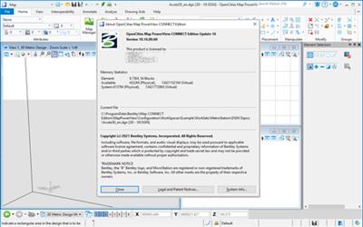
Product: OpenCities Map PowerView
Version: CONNECT Edition Update 16 (10.16.00.60)
Supported Architectures: x64
Website Home Page : http://www.bentley.com
Languages Supported: english
System Requirements: PC *
Size: 3.42 Gb
百度网盘下载:
本站解压密码:caxfwz


请先 !